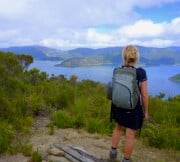
The tablelands of the north-west South Island are a remnant of once extensive sea-level plain which over 45 million years ago stretched across New Zealand. In the last 14 million years the plain has been uplifted. It is made of marble and limestone. Limestone is mostly calcium carbonate, which came from the skeletons or shells of small sea animals which settled on the sea floor millions of years ago, and were compressed to form rock. It is often rich in fossils. Marble is limestone which has been metamorphosed by high temperature or pressure deep within earth's crust into a harder rock. Together limestone and marble constitute 5-10% of the earths surface. Karst is a term for a limestone landscape and comes from a region in Slovenia. Under the eastern flank of the Mt Arthur Range, two very large cave systems have been discovered: Ellis Basin and Nettlebed. The entrance of the Nettlebed was discovered in 1969, and, over the years, 25 kilometres of passages have been mapped by speleologists. From the cave's highest opening (Blizzard Pot) to its lowest level is 889 m, making it New Zealand's deepest cave. Ellis basin cave system is longer, but not quite as deep as Nettlebed, though new sections are still being discovered. Mt Arthur is hard crystalline marble, and nowhere else in New Zealand is there such a complex series of ancient rocks eroded into such distinctively different landscapes. Ice ages carved out cirques high on Mt Arthur. Caves are formed when limestone/marble is dissolved by water. Water with dissolved CO2 is slightly acidic, more so when tannins leached from the forest are in it. It reacts with CaCO3 gradually dissolving it, and carving caves where streams flow through fissures in the rock.
The Paparoa range – a backbone of rugged granite peaks and a lowland belt of limestone, carved by water into canyons, caves, and sinkholes. Sheltered by mountains and nurtured by a warm moist ocean current, this area has a subtropical microclimate with lush vegetation, giving the appearance of tropical rainforest.
As water dissolves the limestone it becomes saturated with CaCO3. When the saturated solution drips from the roof, any evaporation of the water causes the CaCO3 to precipitate out of solution i.e. it becomes solid again. This can cause a stalagtite to form at the point the water drips from, or a stalagmite to form on the ground where the drop lands. A range of shapes can form by variations of this process: straws, pillars, curtains.
Pancake Rocks
Limestone, formed by sedimentation of shell debris, accumulated and compressed over millions of years, and then uplifted. The sea then forced its way under this geological formation, creating surge chambers and blowholes, that can explode with extraordinary power in the right weather conditions. Also wind and waves have sculptured a range of towers, pinnacles and faces in the rock.

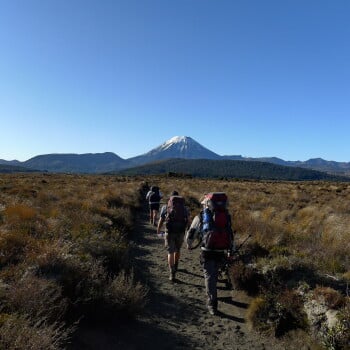
Glaciers are rivers of ice which are fed by snowfall at their head, and flow down valleys until they reach a lower altitude where it is warm enough to melt them. North west winds pick up moisture from the Tasman Sea and bring 15 metres of rain at 1500m, which delivers 45m of snow at 2500m. The accumulation of snow feeds the Fox and Franz Josef glaciers, two of the few in the world which come right down into rain forest. Fox and Franz are special because of the low level snouts and speed of movement. During 1965-67 the glaciers advanced 1-8m a day. The neve is the top part of the glacier, the huge collecting snow-field. New snow compresses the air out of old snow to form firn, which in turn is compressed further into blue ice. Gravity shifts the mass downward, and under the strain crevasses appear, which are the distinctive linear cracks that cross the glacier, especially where the incline increases, or there’s a corner. Where the glacier is squeezed at the narrowest and steepest part of its descent you will see the ice-fall, a mangled bunch-up of crevasses and seracs, isolated pinnacles of ice. Rock that has been crushed and dragged down by the glacier is called moraine. It collects at the sides of the glacier, on the surface, and at the terminal. Often, glaciers have terminal lakes, though this is not the case with the Fox and Franz glaciers, where you can the see the river gushing out from an ice-cave directly under the glacier. The ‘milkiness’ of the river is caused by glacial flour, which is a fine mass of silt and grit eroded by the glacier. Franz Josef Glacier was named after the emperor of Austria by the surveyor/geologist/explorer Julius von Haast. Haast named many mountains after his friends back home. The Maori called it Ka Roimata o Hinehukatere ‘the tears of Hinehukatere’. Fox Glacier has its own name, Te Moeka o Tuawe ‘the bed of Tuawe’. There are glaciers on almost every continent of our planet, covering 11% of the land surface and locking up 90% of the above ground freshwater (85% is in Antarctica alone). Only Australia supports no permanent ice today. New Zealand has 3153 glaciers, except for 18 on Mt Ruapehu, all are scattered over the Southern Alps, comprising some 116 sq km of ice.
Fiordland has been shaped by glaciers. This is evident from the shape of the valleys, which are U-shaped meaning they have steep walls and broad flat floors. In contrast, valleys carved by rivers are described as V-shaped. The glaciers in Fiordland were carving these valleys during the last ice age, 20,000 years ago, when the sea level was 100 m lower due to much of the water being locked up in ice. When the climate warmed, the glaciers receded to the mountain tops, leaving deep troughs which filled with water forming the lakes. Also sea levels rose flooding some valleys to form the fiords e.g. Milford Sound. Much of Fiordland is made of very old hard rocks (metamorphic e.g. gneiss; plutonic eg. granite), hardened by pressure and heat beneath the earths crust then uplifted. Thus the steep valley walls cut by the glaciers have been slow to erode further and so remain near-vertical, giving the place its stunning topography.
The Tasman is NZs largest glacier at 28 km long and up to 3 km wide. It once extended another 50km to the end of Lake Pukaki, which filled as the glacier receded. The Tasman glacier is up to 600m deep, and at the snout, still some 200m thick, the ice is 500 - 800 years old. It fell as snow long before Abel Tasman caught the first glimpse of the craggy skyline of the Southern Alps. Most people are rather disappointed at the ‘absence’ of the Tasman glacier. Instead of seeing a splendid vision of a crystal-white river, with ‘icebergs’ calving in a deep blue lake, the visitor sees a huge pile of rubble, finishing in a grubby lake and a thick dirty river. The glacier is there alright, and the rubble is only a metre deep in places, on top of 200m of ice. All glaciers are huge grinding mechanisms, carrying large amounts of mountain debris to the plains. Some of this material is held suspended in the glacier. Because this glacier is receding, the debris is much more evident. The terminal lake of the Tasman Glacier was only a few sinkholes twenty years ago, and a fifty years ago you would have had to walk up from the road to get onto the glacier. The lake is likely to go on increasing in size quite rapidly.
The Hooker and Mueller glaciers illustrate well glacial features such as lateral and terminal moraines, and the terminal lakes created by recession of glaciers. The Hooker river shows the cloudy grey colour imparted by glacial flour, the fine rock dust ground by the glacial movements. This flour at lower concentrations gives lake Pukaki its bright opaque turquoise colour.

Pounamu is a term applied to nephrite, known as jade in other countries, which is found in the Arahura and Wakatipu regions, and in many rivers and beaches between Jackson Bay and Martins Bay, and bowenite (which is a type of serpentine) found at its most significant site at Anita Bay in Milford Sound. Bowenite is lighter in colour and called by the Maori ‘tangiwai’ meaning ‘tear water’. The exceptional hardness of greenstone made it highly desirable for weapons of war, and its beauty, desirable for ornaments. One account refers to greenstone as ‘kai kanohi’, ‘food for the eyes’. The Maori recognised several types of greenstone – kahurangi (light coloured), kawakawa (dark coloured), inanga (whitish, sharing the same name as whitebait) and tangiwai (transparent). Only in the South Island could the valued mineral be found, and the most abundant source was in the Arahura and Taramakau valleys. The Maori had regular trails and knowledge of the Haast Pass, Browning Pass, Harper Pass, Whitcombe Pass, and Lewis Pass. Greenstone is not always obvious in its natural state, for usually there is an outer rind of rock that could be anything from almost white to deeper browns. The Maori traditionally looked for greenstone when it was wet, after storms or an outgoing tide, when the greenstone was more easily distinguished. Often some of the best greenstone pieces can be found on the coast, as they have survived the natural ‘grinding’ mechanisms of river and shingle. The milky-green inanga was particularly prized by the Maori.
There are over fifty hot springs or seepages throughout the South Island, mainly associated with the Southern Alps and the Alpine Fault. This fault line is the consequence of the two tectonic plates that New Zealand sits astride, and literally moves mountains, such as the Red Hills; one part is still in South Westland, while the other has been slid up to Nelson. There are two commercial hot springs in the South Island, both on the Lewis Pass road, at Maruia Springs and Hanmer Springs. Natural hot pools contain microorganisms which are adapted to life at high temperatures – they have special heat stable proteins (enzymes) which can carry out the biochemical reactions on which life depends at temperatures which would destroy the proteins of most organisms. Some of the green slime in the pools is an algae called blue green algae (or cyanobacteria) which is the most simple primative type of algae i.e. one of the earliest types of plant which evolved. It can photosynthesize but its cells don’t have nuclei, which is a characteristic of bacteria rather than algae.

Lakes Wanaka, Hawea and Wakatipu all lie in hollows carved out by glaciers 20,000 years ago, and the surrounding hills shows the rounded forms sculptured by glaciers i.e. hillsides smoothed and contrasting with the jagged peaks above. Look out for roches moutonnees (sheep shaped rocks) isolated rounded hills with a smooth side where the ice rode up and a rougher steeper side where the passing ice plucked out pieces of rock. This area was opened up by gold prospectors in the 1860s, then settled by high country sheep farmers. More recently it has become a popular recreational area with trout fishing and boating on the lakes and rivers, tramping in the mountains, and skiing in winter. Numerous vineyards have sprung up in the last 20 years taking advantage of the hot dry summers, gentle autumn conditions, and plentiful irrigation water.

The Green Lake landslide in Fiordland National Park, may be the largest of its type on earth. (Surpassed only by submarine and slow creeping slides). It covers an area of 45 sq.km and the volume of earth that moved was 23 cubic km. The landslide occurred about 12,000 years ago and was probably due to an earthquake. A 9km segment of the Hunter mountains moved 2.5 km laterally and 700m downwards, creating a landslide dam 800m high. It formed an 11 km long lake which has since been filled in by glacial sediment, through which the Grebe river now flows. The debris formed the shelf which now holds Green lake and Island lake.
On the shelf of landslide debris holding Green Lake and Island Lake are other depressions where tussock grows rather than beech forest. These may be old lake beds which have since silted up and infilled, where beech has not yet had time to establish. But there is another possible reason that beech forest does not grow there. These basins trap cold air forming a temperature inversion, so that although they are below the bushline, it is too cold for beech forest to grow. This is well illustrated by frosty nights spent camping at Green Lake – remember it is warmer camping under the beech trees.

The fossil forest at Curio Bay is one of the most extensive and least disturbed in the world and the processes that brought the trees to this state and left them ‘beached’ on the remote and tranquil Catlins coast, were complex, and almost entirely violent. The fossilised forest has a history that goes back to Gondwanaland. This ancient super-continent comprised much of Antarctica, Australia, Africa, India and South America, and existed about 180 million years ago. Curio Bay forest then would have looked similar to New Zealand rainforest today - luxuriant ferns, and trees like kauri and matai. A few dinosaurs, but no birds, and much of modern New Zealand at that time was under water. Volcanic activity repeatedly buried the forest with ash, then new forest grew, and then another reburial. This happened at least four times, and then these sediments were buried deeply and silica minerals invaded the woody tree stumps and quite literally turned them to stone. Finally, the rock was brought to the surface, and eroded by the sea to expose the fossilised tree stumps - a remarkable transformation.
Central Otago is a fragmented schist plateau, characterised by dramatic schist tors. The huge grinding process of weathering does its work unevenly, and some schist rocks are better at resisting than others - hence these columnar tors. Lichens have seized a hold on the rocks with some striking colours, in contrast to the brooding, almost sinister shapes of the tors.
The Central Southern Alps are made of a rock called greywacke, which weathers quickly. Its numerous cracks and weaknesses take up water, and when this freezes and expands, the rocks are fractured. The result is scree – a slow moving conveyor belt of rock debris. This is a unhospitable environment: unstable and subject to extreme temperatures. The plants which manage to survive on scree often have deep roots which reach down below the layer of mobile rocks into underlying moist sandy soil. The roots store reserves of energy so that if the surface parts of the plant are damaged, new parts can be grown. Colouration may be cryptic (blueish grey) to hide the plant from grazers, and surfaces waxy to prevent dessication.
Mount Somers is an old volcanic rhyolite dome, quite distinctive from the greywacke that makes up most of South Canterbury. It is not an actual volcanoe (like Ruapehu) but magma squeezed up through a crack. The hard volcanic rock of Mt. Somers withstood glaciation, and has created an interesting topography with rock outcrops, waterfalls, and narrow gorges.

The largest plains in NZ (300km x 100km). Geologists estimate that less than a million years ago the waters of the Pacific Ocean lapped against the base of the Southern Alps, but slowly, by glaciation, and by the action of the great braided rivers (Waimakariri, Rakaia, Rangitata), the mountains were eroded and the debris in the form of stones and gravel was carried down to the sea. These coarse gravels were deposited at the river mouths in great fan-like deposits, pushing simultaneously seawards and sidewards to eventually join up and form the Canterbury Plains. At the intersections of these deposits, smaller rivers such as the Ashley, Selwyn and Ashburton now flow. Gravel deposits reach depths of up to a kilometre, soil is only 20-25cm, mostly made up of loess (wind blown soil). The Canterbury Plains was covered by totara dominated forest 2000 years ago, then huge fires devastated many trees. After the arrival of the Maori, much of the remaining forest of the Canterbury Plains was burnt, probably to allow bracken, the source of fern root, to establish itself.
One the most distinctive habitats are braided rivers, huge channels of gravel that carve right across the Canterbury Plains and the MacKenzie Country, swirling with dust when the nor’wester blows. Plants and particularly birds have managed to establish themselves quite successfully in these arid and dynamic areas - over thirty bird species have been identified as using braided rivers, notably of course the wrybill and the black stilt.
Made up of the remants of two basaltic volcanoes, Lyttleton and Akaroa which became extinct about 5.5 million years ago. Until the recent geological past, this area was an island, but was joined to the mainland by the gradual eastward movement of the Canterbury Plains.
The cliffs are sandstone with sea caves carved in at their bases. The beach is covered in rounded pebbles – all about the same size, but who sorted them so precisely? Particle size on beaches is determined by wave action. Turbulent conditions produce steep shingle beaches, which drain quickly and contain little organic matter, and are too harsh for living creatures. Smaller waves give moderately sloped sandy beaches whose smaller particles hold some water and often have shellfish buried beneath. Calm conditions create mud flats rich in organic matter (organic materials break down into small particles which settle out with fine mud particles) and good at holding water, where snails, crabs and mangroves can survive at the surface.


Arguably, the outcome of Aotearoa’s most important annual election amongst our feathered friends hol…
Heading to Christchurch for a weekend away, visiting a friend or family, or as part of your travels …
Sometimes you wonder if the weather actually cares what season it is in New Zealand. We have some lo…
Did your Leki poles weld themselves together again?
I (Malcolm) went to use my alloy Leki walking …